 The visitor of Tinos must bear in mint that, beyond the pilgrimage to the church of Virgin Mary an exploration of the inner landscape of the island is advised. The rural areas of Tinos have managed to stay almost unaffected by external influences until today. The ambler will walk through cobbled roads and paths, enjoying the rocky surroundings of the Tinian hinterland, lined with dry stone walls, made by brilliant builders, who managed to make them merge with the environment. He will also have the chance to enjoy remote dove-cotes, "embroidered" with unique expertise by stone-carvers, country cottages and chapels with artistic bell-towers, but also green ravines that embellish the peaceful scenery.

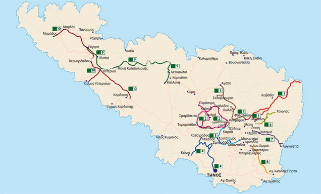
The routes below are only some of the various alternatives suggested to the hiking devotees.
1
"FALATADOS- (MYRSINI)- MAGGANARI- PLATY- LIVADA COAST"
 This route presents a great interest, while the foot passenger, starting from "Falatados", one of the biggest and most beautiful villages in Tinos, has the chance to walk on a cobbled path for the biggest part of the way, through the shadowy waterside of the adjacent creek with the rich vegetation of sycamores and oaks and explore locations with old watermills. At the site named "Lidakia", the scenery is spectacular, with innumerable weather-beaten big granite rocks. The wandering can end through the rural areas of "Plati" and "Magganari", at the coast of "Livada", a beautiful and clean beach. Further, the excursion can be extended to the lighthouse of "Livada", located at the north-eastern coast of the island. The same destination can be reached when starting from the village "Myrsini", situated at the root of mount "Tsiknias".
2 "XYNARA- XOMBURGO- KOUMAROS-SKALADOS- KROKOS- SMARDAKITO- TARAMBADOS- KAMBOS- LOUTRA- PERASTRA"
It is a long and tiring route but following it can be worthwhile, because the tourist will have the chance to know many villages of the hinterland, passing through them and experiencing the grandeur of the natural scenery along the way. Starting from the village of "Xynara", head of the former "Xomburgo" borough, where the noble and impressive building of the Catholic archbishop stands, the sight-seer can climb up to "Xomburgo" which overhangs this village, casting its shadow imposingly. At the top of the castle, the panoramic view is breathtaking, while the large marble cross presents a great interest. It was erected in memory of the old church of Saint Helen that had been there. Afterwards, the road goes through "Koumaros", along the slope of the mountain "Fourka", with a view to the valley of "Komi" and its villages. Having the unique landscape of "Volax" with the huge granite rocks on his right, the hiker arrives to the nearest village, "Skalados", where he can have a coffee break or a get a soft drink at the village coffee-shop. The way down will continue to "Krokos", a picturesque village in the ravine with traditional taverns. The route afterwards becomes steep but pleasant, while it continues through a path between fields with water creeks and fruit trees. Coming across picturesque chapels, dove-cotes, threshing grounds and windmills, the tourist will reach "Smardakito", a village with nice surroundings , architecture and a cool water fountain where he can rest.
Continuing to "Tarambados" the tourist will have the chance to enjoy the marvelous sight of the artistic dove-cotes, grouped together and considered among the biggest and the best preserved ones in the whole island. He will carry on to the nearby village of "Kambos", where he can buy wonderfully smelling loafs of bread. Further, he will reach the village of "Loutra", with citrus groves and the former convent of the Ursuline nuns and Jesuit monks. At the end, he will arrive at "Perastra", walking alongside the valley of "Komi", among oleanders and osiers, passing through stone bridges and marble-paved alleys.
3 "KEHROVOUNI ABBEY- MOUNDADOS- SBERADOS- TRIPOTAMOS- XOMBURGO"
This route that starts from the "Kehrovouni" abbey and ends in "Xomburgo" or vice- versa, can be compared to communicating vessels where the beginning and the end are located on the peaks of the two mountains with the same altitude.  Thus, anyone that tries to walk has to expect climbing many steps, but this will be very rewarding, while besides the physical exercise, he will have enjoyed a fabulous route. From the abbey starts a cobbled twisting path, going down the slope with the fields and the innumerous terraces, the stables and the threshing grounds and ends up in the village "Moundados". Here the tourist has the chance to visit the beautiful and picturesque village and rest a little, drinking water from the village fountain. Afterwards, passing over a stone bridge and leaving behind on his right the village of "Karya" and the hill of "Kolokithas" with the abandoned windmill, he will reach the villages "Sberados" and "Tripotamos". Both are traditional thorps, charming the visitor with several dove-cotes, marble fountains and chapels scattered around them. After the village of "Tripotamos, the road becomes steeper and coincides with the ancient road to "Xomburgo". The route, passing through the ruins of the ancient city with the remnants of the imposing ancient wall, the interesting buildings and the Sanctuary of Ceres, reaches the foothill of the rock that for centuries stood as the medieval castle of the island. Furthermore, the visit can be completed with a tour of the cloister of the "Holy Heart of Jesus", but also with the climbing of the rocky hill, for those who are able climbers.
4 "KIONIA- KTIKADOS - SMOURDIA- VARY - POLES- CHORA"
 The two smaller paths of this route are those that connect the villages "Ktikados" and "Hatzirados" with "Kionia", a seaside touristic settlement with an ancient sanctuary, where the ruins of the Temple of Poseidon and Amphitrite exist. They are quite short and effortless walks, since they lead downhill, but they are enjoyable and offer a great view to the endless Aegean sea and the nearby island of Syros. The hiker will pass through rural roads and bridges in the vert. This part of the route is connected with the marble-paved road between "Chora” and the fortress of “Xomburgo", passing through the ruins of the ancient wall of Tinos at the location "Poles", as well as the ruins of the Peisistratus aqueduct. If someone wants to follow the whole route, one has to start from "Hatzirados" or "Ktikados", pass through the ruins of the old village and the position "Smourdia" and go down the cobbled road of "Xomburgo-Chora".
5 "FALATADOS- VOLAX- GRIZA- SKLAVOCHORIO- AGAPI"
 This route leads from the "Pano Meri" to the "Kato Meri" of Tinos, starting from the north edge of "Falatados" and particularly "Kathlikados", ending at the village of "Agapi". The ambler, after passing through a unique landscape with massive granite rocks, will arrive at the village of "Volax". A tour around the picturesque village and the purchase of traditional baskets are a must, as well as a stop at the coffee house and tavern of the little village. Afterwards, heading to the village "Griza" along the valley with the briers and oleanders, he will arrive at the village "Agapi" with the stone bridges, many dove-cotes, the prickly pear cactuses and almond trees. Through a small sidetrack, the ambler can visit the small village of "Sklavochorio", birthplace of the painter Nicholas Ghizis.
6 "STENI- POTAMIA- MAROULI- LIHNAFTIA"
 If someone visits "Steni", head village of Tinos, and likes hiking and exploring, it is preferable to follow the path that starts here and goes down to the southeastern part of the island with an ending at the vert and the peaceful "Lihnaftia" beach. During the route he will come across the village "Potamia" with its ravines, will walk on the old road of "Tartari", after he has passed through the stone bridge and while going down to the village "Marouli", he will meet traditional dove-cotes built inside gardens. At the site called "Neromilos" it is nice to rest and see the old thorp with its watermill. The end of this route is the magical beach of "Lihnaftia" with the colorful pebbles, green waters and the view to Mykonos.
7 "MYRSINI- PROFITIS ELIAS- TOP OF TSIKNIAS"
 The island visitor will have a view of the entire island of Tinos if, apart from the other routes, he also follows the one that leads to the top of mount "Tsiknias"(726 m), with many myths around its name. Starting from the village "Myrsini", he takes the path to "Xokopi" that leads to the foothill of the mountain. At the location "Marmaras" the serpentine ascension starts, heading to the chapel of "Profitis Elias", and finally ending at the top of the mountain. Here, the ambler is rewarded for his choice, because the view of Tinos, the Aegean and the islands all around, is all in front of his eyes.
8 "DYO CHORIA- FANEROMENI- KOUNARES- (AGHIA VARVARA)- AGHIOS SOSTIS
With "glysterni" (that is the lower village fountain) in Dyo Choria", as a point of departure, the foot wanderer can follow the old snaky path and go down the slope having an endless view of the sea. In the front, one can see the pastures of "Mantalous", while, all around, one can find chapels and olive groves. Arriving at the Abbey of "Faneromeni" and at the site called "Kounares", it is worth making a stop to admire the scenery and watch the ruins of the ancient thorp. After "Kounares", the route is divided into two sections:  one of them leads to "Aghia Varvara" and the other one- the main route- to the picturesque port of "Aghios Sostis" with a beautiful beach.
9 "KALLONI- AETOFOLIA- KORIS PYRGOS- STAVRIA- MONI KATAPOLIANIS- PLATIA-PYRGOS"
The wanderer deciding to walk this long route of great cultural interest in order to reach "Kato Meri" and "Exo Meria", will have the chance to get a unique experience, because he will discover the unexplored side of Tinos. He will walk from "Kalloni", (meaning beauty) a really pretty village, as its name reveals, and continue up to "Aetofolia" with the great view and the picturesque source. He will pass the stone- bridge and will reach "Agioi Anargyri" church and "Pyrgia", where ruins of the Hellenistic era exist.
Heading always to the north side of Tinos with the steep slopes and the wild insular nature, having on the right side the Aegean, the tourist will stop at the position "Koris Pyrgos", to enjoy the marvelous view of the dell of "Halakia" and the country cottages of an ancient thorp. During the whole route the scenery is dry, with poor vegetation and fields with the characteristic terraces, built with local rock. The next station is the Abbot of "Katapoliani" dated from the 18th century. It is located at the slope of the mountain in the area of "Ysternia" and has a great view to the villages of "Exo Meria" and a source with cool water. Afterwards the track is going down to the village of "Platia" with the war memorial, dedicated to the "Panormos" inhabitants lost in war. The final destination is "Pyrgos", the biggest village in Tinos. Here the tourist can walk through the marble-paved alleys, visit the Museums of "Halepas" and "Artists of Panormos", the School of Marble Art, the village cemetery with its impressive sculptures, the new Museum of marble Art, admire the rare lintels and rest at the picturesque square of the village with the centenarian plane-tree.
10 "KARDIANI – YSTERNIA -(COAST OF YSTERNIA)- VENARDADOS- PYRGOS- MARLAS- MAMADOS"
Having the village of "Kardiani as a point of departure, (a green village on the southwest side of Tinos that literally hangs on the slope of the mountain with an imitable view to the Aegean and Syros,) the ambler moves further on a path parallel to the provincial road to "Ysternia", a big and beautiful village with a view comparable to that of "Kardiani". Here, one can stop in order to walk through the marble-paved alleys, visit the Museum of the Artists from "Ysternia" and the ornamented cathedral of Saint Paraskevi. If he wishes and has some time to spare, he can walk down the old cobbled path with stairs to the coast of "Ysternia", where he can sit for coffee at the coffee-shop or for sea food at the taverns. Otherwise, he continues for "Pyrgos", passing through the picturesque village of "Venardados" which is located in a ravine with plane-trees. Afterwards, one can reach the biggest and most beautiful village of Tinos, "Pyrgos", and further take the old cobbled road leading to "Panormos". Later, he can follow an uphill branch of the road to the village of "Marlas" with the beautiful church of Ag. Anargyri and the neighboring monastery of Kyra-Xeni, as well as the village of "Mamados", the island's outmost village to the west, with a great view to the channel Tinos-Andros and Andros island itself. Meanwhile, he can explore the thorp of "Ismael", which is lying in ruins.
|